Log in
All resources
Create a design
9,296 Free Artworks of Map Collection
bibliothèque nationale de france
john rocque
remigius parr
john rocque's 1748 map of london and adjacent country
maps from gallica
beschreibung der städt der welt - braun & hogenberg - btv1b52512111k
map of europe by nicolas and guillaume sanson (1669)
guides joanne
louis cordier
国立国会図書館
john rocque's 1748 map of london and adjacent country
remigius parr
17th-century maps of iceland
iceland map by joris carolus
john rocque's 1748 map of london and adjacent country
remigius parr
john rocque's 1748 map of london and adjacent country
remigius parr
john rocque's 1746 map of london
remigius parr
bibliothèque nationale de france
maps by john rocque
john rocque's 1748 map of london and adjacent country
remigius parr
john rocque's 1748 map of london and adjacent country
remigius parr
john rocque's 1748 map of london and adjacent country
remigius parr
john rocque's 1748 map of london and adjacent country
remigius parr
john rocque's 1748 map of london and adjacent country
remigius parr
dutch 18th-century prints in the rijksmuseum amsterdam
symbols of roermond
maps from gallica
guides joanne
eran laor cartographic collection
willem albert bachiene
illustrations about measurement in the deutsche fotothek
birckenstein handgriffe (image set)
satirical prints in the british museum
the troelfth cake
satirical prints in the british museum
the troelfth cake
le comté de la marck, les seigneuries des abbayes de werden, d'essen et la ville impériale de dortmundt - dressé sur les mémoires les plus récents par le sieur sanson... - btv1b532024306
guillaume sanson
cornell: persuasive cartography: the pj mode collection
cartographers
cornell: persuasive cartography: the pj mode collection
slavery in the united states
venezuela cum parte australi novae andalusiae - (willem janszoon blaeu et joan blaeu) - btv1b8596474b
17th-century maps of venezuela
atlas, ou représentation du monde universel et des parties d'icelui, faicte en tables et descriptions très amples et exactes, divisé en deux tomes. édition nouvelle... - btv1b53103889w
maps facing west
jean-fréderic phélypeaux
guillaume dheulland
1700s maps of the netherlands
maps by nicolas sanson
françois de la pointe
1620s maps of france
map of the circle of westfalia by sanson
louis cordier
1631 stadtbrand von isny im allgäu
baroque
maps from university of amsterdam special collections
atlas der neederlanden
1770s maps of rhineland-palatinate
maps of east palatinate by sanson
maps by pieter mortier
maps from gallica
utagawa school,kasei culture,ukiyo-e
ndl-dc 1307521 tōto meisho zu
l'empire d'allemagne divisé en ses dix cercles, et ces cercles en leurs principaux estats, principautés et souverainetés ecclésiastiques, laiques et villes impériales avecq le royaume de boheme et les... - btv1b53202355w
sanson maps of the circles of germany
lionnois, forest, beauiolois et masconnois (old maps)
maps by willem and johannes blaeu
1565 maps of asia
niccolo nelli
mappe-monde geo-hydrographique (sanson and jaillot, 1674)
louis cordier
utagawa school,kasei culture,ukiyo-e
ndl-dc 1307521 tōto meisho zu
mappe-monde geo-hydrographique (sanson and jaillot, 1674)
louis cordier
sanson maps of south america
louis cordier
utagawa school,kasei culture,ukiyo-e
ndl-dc 1307521 tōto meisho zu
bibliothèque nationale de france
maps by thomas kitchin
maps of ancient israel by philippe de la rué
old maps of the stations of the exodus
bibliothèque nationale de france
sanson maps of north america
beschreibung der städt der welt - braun & hogenberg - btv1b52512111k
maps of la rochelle by braun & hogenberg
map of europe by nicolas and guillaume sanson (1669)
bibliothèque nationale de france
maps of andalusia by mercator-hondius
bibliothèque nationale de france
beschreibung der städt der welt - braun & hogenberg - btv1b52512111k
hierosolyma clarissima totius map by braun & hogenberg
map of europe by nicolas and guillaume sanson (1669)
bibliothèque nationale de france
maps of italy by sanson and cordier
bibliothèque nationale de france
map of europe by nicolas and guillaume sanson (1669)
bibliothèque nationale de france
bibliothèque nationale de france
sanson maps of asia
maps of italy by sanson and cordier
bibliothèque nationale de france
maps from gallica
guides joanne
bibliothèque nationale de france
sanson maps of asia
maps of andalusia by mercator-hondius
bibliothèque nationale de france
maps from gallica
guides joanne
beschreibung der städt der welt - braun & hogenberg - btv1b52512111k
maps of tunis and la goleta by braun & hogenberg
map of the circle of austria by sanson
context files from gallica
bibliothèque nationale de france
sanson maps of asia
map of europe by nicolas and guillaume sanson (1669)
bibliothèque nationale de france
beschreibung der städt der welt - braun & hogenberg - btv1b52512111k
maps of schwäbisch hall by braun & hogenberg
map of europe by nicolas and guillaume sanson (1669)
bibliothèque nationale de france
map of europe by nicolas and guillaume sanson (1669)
bibliothèque nationale de france
beschreibung der städt der welt - braun & hogenberg - btv1b52512111k
maps of frankfurt (main) by braun & hogenberg
map of europe by guillaume sanson (1674)
guillaume sanson
ndl-dc 9369963 dainihon rekishi nishiki-e
utagawa yoshitora
bibliothèque nationale de france
cartouches by tomas lópez
chambre des députés (july monarchy)
maps from gallica
maps from gallica
guides joanne
bibliothèque nationale de france
sanson maps of asia
beschreibung der städt der welt - braun & hogenberg - btv1b52512111k
maps of ancient rome by braun & hogenberg
beschreibung der städt der welt - braun & hogenberg - btv1b52512111k
hierosolyma urbs sancta map by braun & hogenberg
portrait paintings by giuseppe duprà (house of savoy)
portrait paintings of marie josephine louise of savoy
josef fleischmann
brehms tierleben
accademia delle scienze di torino - fondo millon
media from accademia delle scienze di torino
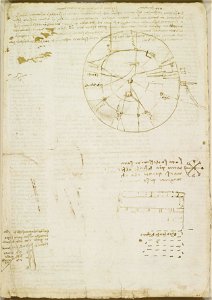
drawings by leonardo da vinci in the royal collection of the united kingdom
high renaissance,renaissance
drawings by leonardo da vinci in the royal collection of the united kingdom
high renaissance,renaissance
theodor matham
frans koerten
british library asia, pacific and africa collections
twenty-four views by henry salt (1809)
maps from gallica
guides joanne
joseph fleischmann
brehms tierleben
flora from the british library mechanical curator collection
wanderings, south and east (1882)
floris balthasarsz. van berckenrode
17th-century maps of amsterdam
hmnb devonport
samuel buck
maps from the mechanical curator collection
realism
atlas schoemaker-noord-holland
old maps of beverwijk
picturesque journey to the two americas, asia and africa
lima in the 1840s
west-indische compagnie
1665
view of kraków by abraham hogenberg (national museum in warsaw)
river transport in the polish-lithuanian commonwealth
theatre oft toonneel des aerdt-bodems (1571 kb)
typus orbis terrarum
genre paintings by gerard ter borch (ii)
baroque
french-language maps of north america
1809 maps of north america
drawings by leonardo da vinci in the royal collection of the united kingdom
high renaissance,renaissance
iconografia della ducal basilica dell'evangelista s. marco
plans of st. mark's basilica (venice)
art in the national library of new zealand
works after charles heaphy
maps of ancient israel by philippe de la rué
bibliothèque nationale de france
map collection of leibniz-institut für länderkunde
1720s maps of the iberian peninsula
maps of wales by humphrey llwyd
maps by pieter van der keere
maps of provence by pierre-jean de bompar
bibliothèque nationale de france
17th-century maps of vienna
maps by nicolaes visscher i
maps of the iberian peninsula by mercator-hondius
maps by pieter van der keere
6201 - 6300 of 9,296
Next page
/ 93


![Tongariro and Ruapahu, seen from Mount Ngariha towards the southeast. Plate 8. Dr F. Hochstetter del. Whakari or White Island. Ch. Heaphy, Conrad Grefe, [1864]](https://cdn.creazilla.com/illustrations/7230338/tongariro-und-ruapahu-vom-berge-ngariha-aus-gegen-sudost-gesehen-taf-8-dr-f-hoch-md.jpeg)